How to get there:
A very convenient location from where to start is the
DNT hut Vikerkoia. One may drive a toll road
starting from the west side of lake Sperillen to reach this hut.
The main highway E-16 runs on the east side of the lake, the connecting road
is at the south end.
There is parking very close to the hut at location
N60.44740, E009.95713, elevation near 650 meter.
Route::
Walk along the main road until you cross a small creek.
Contine a short distance, then observe a signed trail that
goes right. Take this trail. It is marked with blue paint.
The trail climbs to a local col, then descends slightly to lake Svarttjern.
Next, the trail descends more before a more level section to the lake Steintjern.
Continue on the west side of this lake, a bit later the route bends left and climbs a
local (small) hill with a huge boulder on top. There are trail signs here and several
trails. When arriving uphill following the blue markers, one should turn quite a bit
left at the big boulder in order to continue along the trail that climbs to the summit.
The route is still well marked with blue paint as it heads more south-west before the
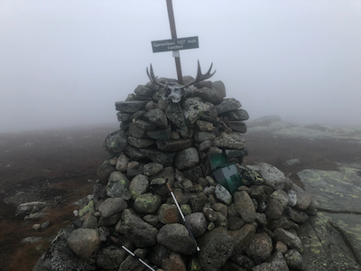
final ascent to the summit plateau. Finally,
a short walk to the cairn marking the
highest point.
Comments:
I got up early, cleaned up the hut then started hiking at 0610.
Complete darkness, my torch light worked well. When I got to the small
lake Svarttjern it was still dark, but daylight was on its way.
The night got replaced by pretty dense fog, so visibility remained limited.
I arrived at the summit at 0855, so 2:45 up. The summit was no pace to
spend time, I started descending after a short break.
The return trip took 1:55, downhill and daylight do help!