How to get there:
Locate Hwy. D-17, north of the mountain.
This road head into the valley. Continue into the valley
on D-417. Do not drive up to the ski area called SuperDevoluy.
D-417 sort of ends when crossing a small bridge, turn right after this bridge
and continue on D-147, it will still head into the valley, but on its right
hand side. You will arrive at a road fork with parking space for 5-10 cars.
This is location 44.65751, 5.93506, elevation about 1550 meter. This is a reasonable
trailhead.
The right hand road heads uphill. A 4WD should have no problem with driving to the end
of the road somewhat above 1700 meter. There is space for parking there, close to
a mast that is part of the gondola that runs all the way up to the main crest of this
mountain. (Actually serving some space observatory.)
Note:
There are other trailheads for this peak. One may start from the southwest side. Most likely,
there is also some route from SuperDevoluy.
Route description:
Hike up to the end of the road. Just as it turns left (before ending), a trail continues straight.
Follow this trail as it enters a basin, then climbs to a second basin (on the left side). You will
see the route traversing right more uphill in front of you. Your trail will connect with this traversing
trail. Continue up what looks like the only feasible way. This trail ends with a few zig-zags as it reaches
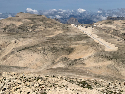
th main crest of the mountain. Quite surprisingly, there are 12 15 meter radio antennas up here. This is NOEMA,
Northern Extended Millimeter Array, one of the most powerful interferometry observatories. The antennas can move
along a 1.7 kilometer straight line concrete "road", and work together to produce a very high sensitivity radio
telescope.
Once you reach this concrete "telescope-road", turn right and walk almost to the end, descend to
the shallow saddle then ascend on easy ground. There is no trail, but the terrain is easy to walk anywhere.
You will soon arrive at the summit with a cross. Pretty nice views across the valley.
Return the same way, it is very likely that you will also visit Pic de Bure,
the highest peak on this mountain.
Comments:
The trip across to this peak took less than on hour including a 10 minute summit
break. See the report on Pic de Bure for more details.