How to get there:
The shortest trail starts from Hope.
Hope is a bit more than 30 km west of Sandane along
Hwy. 615. From Bergen, one should travel north on
E-39 to Førde, then take Hwy. 5 north-west towards
Florø. After a bit more than 35 km on this road, go north
on Hwy. 615 at Storebru to Hope. At Hope, locate a small road with
a sign for Gjegnabu. This road crosses the creek and can (in summer)
be driven to a flat area where a sign tells you that further
driving is not permitted. We parked just before the bridge a bit
further down, this road is rather short anyway.
Note, that due to the avalanche problems reported below, one may
be better off with a longer, but less dangerous approach. Route description:
WARNING: The route described here is dangerous due to
avalanche problems that cannot easily be judged from below.
It is likely only relatively safe from mid to late summer and
until the first snow in the fall.
The marked route from Hope first follows the forest road along
the creek into the narrow valley above. There is a forest road that
forks left (see below), the route continues across a flat area where
there is a sign saying that you may not proceed any further with
your vehicle. Shortly thereafter the road ends and a small trail
continues among trees as it climbs a bit higher than the creek before
reaching a more level area where it again follows the creek. As you
cross a small ridge you should have the rest of the valley in
clear view. Stop and consider your future. The valley ends abruptly,
on your left there are steep cliffs, similarly on the right. The trail
starts climbing very close to the creek (on its left side)
at the innermost part of the
valley. However, the marked trail runs on the left side and arcs over
to this point possibly crossing some snow fields that are the
result of avalanches from above. If there is ANY CHANCE that there may
still be snow on the slopes above the cliffs (generally hard to see from
below), then do not cross the snow, but proceed along the creek until
you again locate the red paint on the rocks as the trail climbs steeply
among cliffs just left of the creek.
The route first follows the creek, then climbs very gently left on
a grassy ramp. A bit higher, the route enters a rather narrow ledge
that runs left to right when seen from below, along the cliffs on
your left hand side. Higher up, you will see the creek coming down from
a V-shaped, very narrow cut in the cliffs. The route bends sharply
left on another ledge just before this narrow cut. This turn was only
discovered by us during descent, and therefore never tried. Our route
proceeded straight up along the creek, the last section being on the
right hand side of the creek. The lowest path is blocked at the
upper end by a large rock. We finished this part by climbing on the
steeply sloping rock making the right side of the cut. This climb
was made slightly easier by some snow still present and partly
covering the creek in the bottom of the crack. Still, this was definitely
the crux of the climb.
Above this difficult point you are at about 600 meter and there is a
relatively level area here.
This is the place to leave the valley.
There is a fairly wide ramp going up to your left. The upper side of
this ramp is a very steep and quite high cliff. This cliff continues
uphill (only broken by a steep slope in one place)
all the way to the small lake that is just before
Gjegnabu.
From the guest book at Gjegnabu as well as from a local
farmer we met on our return hike, we learned about an alternative
route (unmarked) that now seems to be preferred by the locals.
As one follows the forest road up the valley, just before entering
a flat area with fire wood, there is a forest road that forks left
and climbs steeply up the hillside. This is the beginning of the
alternate route. The route is called "Lavesteinen", from the view
of a (special?) rock that can be seen higher up. However, this
route is also steep and avalanche prone. As we never checked it
out no recommendations can be made. Check carefully before launching.
Comments:
I made this climb with my friend Arnt Flatmo. We hiked in the
valley and followed the red paint marking until we lost it just
below the 600 meter level. A huge avalanche released on a surprisingly
gentle slope to the left of our route at the 800-900 meter level.
This avalanche proceeded down towards the steeper slope below and then
straight off the near vertical cliffs near the valley floor. It hit
violently and vertically directly on the path (red marked) that we had
walked about 1.5 hours earlier. First lesson: this approach should
not be used in April. Second lesson: if here at this time of year, leave
the trail as it approaches the last part of the valley and continue to
the beginning of the slope (where the creek comes down) along the far
right side. The fact that there is already a (possibly huge) deposit of
avalanche snow on the left slope DOES NOT imply that there will not
be more coming.
Resources:
Images
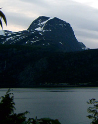
Gjegnen, as seen from the north. This picture has been
provided by Jan Torheim and is taken in June 2004 from Torheim
in Nordfjord.
The route, zoom to see details. Note that the lower part
avoids the avalanche area. From the point of the trail where
this picture is taken, one should check the snow conditions high
up on the left. A major avalanche released AFTER we passed down below.
That is, as it looks on this picture, the situation is NOT safe.
View north from the summit, Saudehornet (left) and the
characteristic triangle shape of Vassdalstinden (right) are both in the
center of the picture. Kolåstinden can be seen further right. The two
peaks in front of Saudehornet are Trollvasstinden (left) and Bytingstinden (right).