Location: North 14.11927, West 89.72555 (GPS on summit)
Climbed: March 20, 2022
Information:
How to get there:
This volcano is located on the border between El Salvador and
Guetemala. In fact, the border crosses near the center of the crater,
thus forming a diameter across the circular rim.
From San Salvador, travel north-west to Santa Ana (town),
continue north-west to San Vicente, the main road continues across the
border to Guetemala. Turn left here and head towards the border, then south-west
to reach the trailhead near a very small village at location
N14.13013, W89.71439, elevation near 1300 meter.
Route::
A quick summary of the peaks climbed in Central America.
From the trailhead/parking, walk into the small community and make
a 90 degree turn (at location N14.12990, W89.71562) to your left in order to follow a small road heading
uphill. At location, N14.12233, W89.72168, elevation about 1450 meter, the road turns into
a trail. Keep right at a fork, then follow the trail as it climbs uphill by actually doing
multiple zig-zag turns.
The trail will gain the rim ofthe volcano, going right along the rim will soon get
you to the point where the border to Guetemala crosses the crater. The summit marker
is a few meter on the Guetemala side. One may continue around the crater following
a fairly good trail.
Comments:
We left our hotel in El Zonte at 0515. The drive went
well and we arrived at the tiny village with the trailhead at 0720.
Leaving at 0730, I quickly got a bit ahead of my party, reaching the
crater rim in exactly one hour. Here I waited for the party to arrive.
We walked around the crater counter-clockwise and arrived at the summit at 0915.
The summit is very close to the border. In fact, if it would have been on the border,
except that the border line makes a small turn around it. Thus, it seems that
the precise summit of this peak actually is in Guetemala.
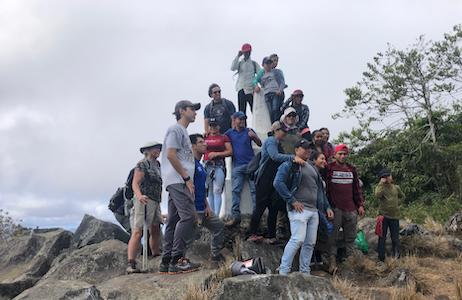
We met a large group of people from Guetemala and exchanged greetings. We continued
around, passing the second point on the rim where the border line crosses.
Eventually, we came back to the point where our trail hit the rim.
Descending, we came back to our car at 1100, so altogether a 3.5 hour trip.