Location: North 60:46.424, East 006:15.255 (GPS at the summit)
Difficulty: YDS class 2
Climbed on September 7, 2008.
Information:
How to get there:
From Bergen, drive E-16 towards Voss, but leave E-16 and turn right across the old railroad
bridge at Evanger (approximately 46 kilometer from the traffic circle at Trengereid). Measure from here.
After 12.2 kilometer, watch for a road fork and turn right (towards Brekkhus) just as the main road makes
a sharp left curve. At kilometer 14, you need to go through a gate. Make certain to close the gate behind
you. Continue up this nice dirt road as it runs through two small tunnels on its way up to lake Store Volavatn.
At kilometer 24.7 you are just below the dam. There is parking on your right side, a few spots are available
at the very end of the road. The location is N60:46.424, E006:16.905, elevation about 930 meter.
Route description:
There is an excellent and extensive description available at Arnt Flatmo's
mountain pages.
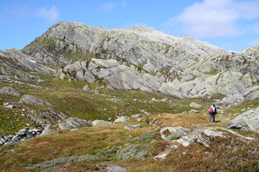
Thanks to the excellent road that brings you into the heart of a very nice mountain area, this hike is actully quite short. You will
see the Kvitanosi mountain from the trailhead, if you look up the small valley that comes down across from where you start out.
Cross the area below the road, you may do this just at the base of the dam, or slightly further down. The important thing to do is
to locate a trail that climbs the valley along its right hand side. See the picture below for more information. There are two
possible routes, on either side of the small mountain called Kvitanosberget. If you follow the trail, then continue south-west
of Kvitanosberget to Bjørndalskjeften. Cross the creek that runs down from Kvitanostjørnan and continue north-west below
the steep side of Kvitanosi. Soon, you will see a distinct ramp that cuts uphill and seems to top out at the very
horizon (see picture below). Hike up this ramp, it provides an easy and good access to the summit plateau area. Once up, hike north
along some permanent snow and to the cairn that is easily visible from some distance.
The alternative is to leave the trail in Snjodalen and head north. This gets you on the east side of
Kvitanosberget. Pass lake Kvitanostjørnan (1206m) and scramble up towards the summit on good rock.
Comments:
I left my car at 1300 and hiked along the trail that took me on the south and west side of Kvitanosberget.
I had given the information
provided by Arnt Flatmo a very quick look before leaving,
noting that he ascended the mountain just after crossing a creek and
that he had assigned a (YDS) class 1 level of difficulty.
(This should correspond to a nice and easy trail hike.) Thus, as soon
as I crossed the creek, I started an ascending uphill traverse.
The terrain was not easy and it got increasingly steeper.
Nothing like class 1 here, as I grabbed small vegetation and balanced on small
ledges with grass and slippery footholds. It looked
easier above me, but hard to get there.
I looked down and considered the wisdom in a continued scramble. My conclusion was
clear; descend back down.
Safely down, I continued along the base and expected to find a way to turn onto the north ridge.
Then, I caught sight of a distinct
line that seemed to provide access to a point high on the horizon. I decided to try this alternative.
This was indeed a very natural way, and soon I could see the cairn slightly north and slightly east. I arrived at the
summit by 1445, quite reasonable considering the extra time I spent on my first attempt to ascend.
There were 4 people already at the summit,
they had hiked in from the end of the road (directly north) at Gullbrå.
I left at 1500 and walked back on the east side of Kvitanosberget,
reaching the car at 1615. Back in Bergen by 1815, where a warm
sauna and a cold beer completed a very nice day.
Resources:
Images
Kvitanosi, as seen from the trailhead. The route heads up this valley.
The ramp, the access from the south-west runs up this ramp.